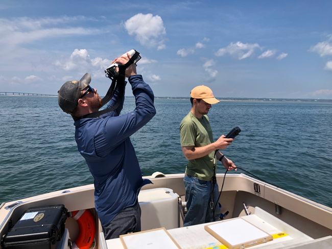
Bio-Optics group members — Postdoctoral Researcher Jonathan Sherman (at left) and Research Associate Kyle Turner (at right) — collect measurements in Long Island Sound. Sherman points a device to the sky to be able to measure the downwelling irradiance (light from the sun coming down to the Earth's surface), which is used in calculations of remote sensing reflectance. Credit: Tzortziou Bio-Optics Lab
— By Chris Gonzales, Freelance Science Writer, New York Sea Grant
New York, NY, August 21, 2023 - Satellites are a useful technology for studying the environment. They have the benefit of being able to see over wide areas of territory and across long spans of time.
Consider, for example, the Long Island Sound, a highly populated estuary of approximately 1,300 square miles. It’s vulnerable to a host of water quality problems, including an excess of nutrients, especially nitrogen. These problems can lead to hypoxia—also referred to as dead zones, where water lacks life-giving oxygen—and frequent harmful algal blooms (HABs).
Still, there are challenges to viewing things such as the tiny phytoplankton that cause HABs from space.
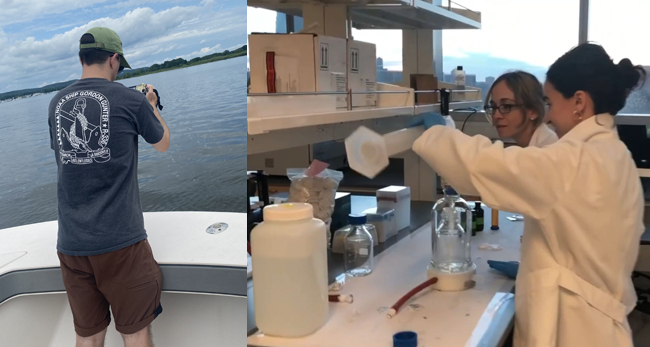
(At left) Research Associate Kyle Turner collects measurements in Long Island Sound, pointing a device to the water to be able to measure the water-leaving radiance (light leaving the water), which is used in calculations of remote sensing reflectance; (At right) Members of the Tzortziou Bio-Optics group (principal investigator Maria Tzortziou [in background] and PhD student Alana Menendez [in foreground]) process samples in the lab in order to develop satellite bio-optical algorithms. Credit: Tzortziou Bio-Optics Lab
Ocean and Sky
Scientists in this field tend to produce studies with two components: observations made by satellites, but then also samples done at the water’s surface—from boats and buoys, say—to check and compare the results of each. In recent publications, scientists have been working on refining and integrating these remotely sensed observations with field data collected at the water’s surface and below.1, 2
These refinements create a more nuanced picture of the region’s ecology, including seasonal and episodic incidents such as river discharge, storm events, and phytoplankton blooms.
“Satellite ocean color observations provide a unique and valuable tool for monitoring changes in estuarine water quality across a range of spatiotemporal scales,” said Maria Tzortziou, the lead investigator on the project, which is supported via a 2019 partnership effort between the Sea Grant programs of New York (NYSG) and Connecticut (CTSG) and the U.S. Environmental Protection Agency through the Long Island Sound Study. Tzortziou is an endowed professor at the Center for Discovery and Innovation at the City College of New York, City University of New York.
The instruments Tzortziou and her team use (in the field or on satellite platforms) are advanced optical spectrometers. These are instruments that measure properties of light over portions of the electromagnetic spectrum. In her team’s work, most of what the scientists observe is ultraviolet-to-visible-to-infrared light.
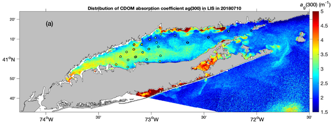
This image shows SENTINEL-3 Ocean and Land Colour Instrument (OLCI) satellite observations on July 10, 2018 over the Long Island Sound for Chromophoric dissolved organic matter (CDOM, one of the main light-absorbing constituents in aquatic systems) absorption at 300 nm (ag(300)). The circles correspond to onsite measurements collected in July 2018, and demonstrate the excellent agreement between field observations and satellite retrievals (from Cao and Tzortziou, In Review). Credit: F. Cao and M. Tzortziou
Deep Dive
Tzortziou and her team have been assessing changes in dissolved organic matter (DOM, a key parameter in estuaries that impacts nutrient cycling, light availability, phytoplankton activity, and overall ecosystem functioning) and transitions in assemblages of phytoplankton—those tiny creatures in the sea, often food at the bottom of the chain for larger fish.
The hope is that development of new and accurate algorithms that connect satellite data to in-water parameters could lead to better water quality monitoring and assessment. This could reduce ecosystem stressors such as HABs and dead zones.
Dissolved organic carbon (DOC) and its colored component CDOM are sensitive indicators of human-caused pollution and conditions of excessive nutrients that can disrupt ecosystems. Both of these can be measured remotely.
In their studies, they were able to determine, for example, how hydrological extremes—both extreme precipitation and droughts—rather than seasonal cycles were a dominant factor affecting variations in CDOM amount and composition across Long Island Sound.
Capturing these episodic events accurately is critical for better understanding and predicting the impact of climate change on this urban estuarine ecosystem.
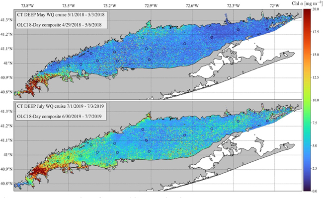
OLCI satellite retrievals of chlorophyll concentration overlapping in onsite measurements from the boat (circles) in May 2018 (top) and July 2019 (bottom). The color bar reflects the values of chlorophyll absorption from both the boat and OLCI. Textboxes in each panel provide the dates in which sampling from the boat occurred, and the OLCI composite date range. Credit: J. Sherman and M. Tzortziou
In their work, the group has developed a new algorithm for retrieval of chlorophyll-a (Chl-a) concentration, which is a good optical proxy for phytoplankton biomass. Application of this algorithm to satellite data allowed them to capture the year-to-year variability in the timing, duration, and magnitude of phytoplankton blooms in LIS consistent with onsite measurements.3 Moreover, the satellite data provided a much finer spatial and temporal resolution. In addition to a clear west-east spatial gradient in Chl-a, the high-resolution satellite images revealed strong transitions in Chl-a between the nearshore and open waters of LIS, as well as in the major river mouths where high nutrient inputs often result in high phytoplankton activity.
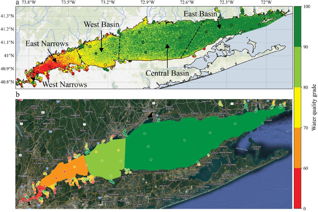
Chlorophyll-a water quality grades calculated with OLCI using their new algorithm (a) and Save the Sound grades published in Save the Sound’s Sound Health Explorer (b). Circles in both panels are the Save the Sound point grades used to grade each region and embayment. Color bar reflects the color scale used by Save the Sound. Credit: J. Sherman and M. Tzortziou
Upshot Effects
Their studies have had other far-reaching implications. Using satellite observations, they were able to identify changes in water quality due to the COVID-19 pandemic, not only immediately after the COVID-19 outbreak, but also as human behavior changed during the multiple waves and phases of the pandemic and across regions experiencing different shifts in mobility patterns. (A separate paper has just been published.4)
They were able to link satellite-retrieved chlorophyll concentrations to estimates of water quality grades relevant to the Sound’s ecological health. These can be used by decision makers and environmental protection agencies involved in water quality monitoring, restoration efforts and future infrastructural investments.
With the aid of satellite monitoring, they were able to make detailed observations across the Sound, unless it was cloudy. These observations would have been impossible at limited point locations.
The scientists on Tzortziou’s team expect that these high-resolution, accurate observations at the ecosystem scale will be highly useful for conservation and ecosystem management efforts.
In all, their findings represent a new way to understand inputs and consequences in the nitrogen and carbon cycles, as well as microbial concentrations and hypoxia along developed coastlines. All of which could lead to better water quality protection.
References
1 Optical classification of an urbanized estuary using hyperspectral remote sensing reflectance. Kyle J. Turner, Maria Tzortziou, Brice K. Grunert, Joaquim Goes, and Jonathan Sherman. Optics Express. Vol. 30, Issue 23, pp. 41590-41612 (2022) doi.org/10.1364/OE.472765
2 Chlorophyll dynamics from Sentinel-3 using an optimized algorithm for enhanced ecological monitoring in complex urban estuarine waters. Jonathan Sherman, Maria Tzortziou, Kyle J. Turner, Joaquim Goes, Brice Grunert. International Journal of Applied Earth Observation and Geoinformation. Volume 118, April 2023, 103223 doi.org/10.1016/j.jag.2023.103223
3 The satellite data was from a sensor called OLCI. The onsite or in situ measurements were from the Connecticut Department of Energy and Environmental Protection, or CT-DEEP.
4 Deciphering the water quality impacts of COVID-19 human mobility shifts in estuaries surrounding New York City. Jonathan Sherman, Maria Tzortziou, Kyle J. Turner, Dianne I. Greenfield, Alana Menendez. Science of The Total Environment. Volume 896, October 2023, 164953 www.sciencedirect.com
More Info: New York Sea Grant
New York Sea Grant (NYSG), a cooperative program of Cornell University
and the State University of New York (SUNY), is one of 34 university-based
programs under the National Oceanic and Atmospheric Administration’s
National Sea Grant College Program.
Since 1971, NYSG has represented a statewide network of integrated
research, education and extension services promoting coastal community
economic vitality, environmental sustainability and citizen awareness
and understanding about the State’s marine and Great Lakes resources.
Through NYSG’s efforts, the combined talents of university scientists
and extension specialists help develop and transfer science-based
information to many coastal user groups—businesses and industries,
federal, state and local government decision-makers and agency managers,
educators, the media and the interested public.
The program maintains Great Lakes offices at Cornell University, SUNY
Buffalo, SUNY Oswego and the Wayne County Cooperative Extension office
in Newark. In the State's marine waters, NYSG has offices at Stony Brook
University and with Cornell Cooperative Extension of Nassau County on Long Island, Brooklyn College and Cornell Cooperative
Extension in NYC and Kingston in the Hudson Valley.
For updates on Sea Grant activities: www.nyseagrant.org has RSS, Facebook, Twitter, Instagram, and YouTube links. NYSG offers a free e-list sign up via www.nyseagrant.org/nycoastlines for its flagship publication, NY Coastlines/Currents, which is published quarterly.